Welcome to DU!
The truly grassroots left-of-center political community where regular people, not algorithms, drive the discussions and set the standards.
Join the community:
Create a free account
Support DU (and get rid of ads!):
Become a Star Member
Latest Breaking News
Editorials & Other Articles
General Discussion
The DU Lounge
All Forums
Issue Forums
Culture Forums
Alliance Forums
Region Forums
Support Forums
Help & Search
Anthropology
Related: About this forumThe Bolivian Lowlands

March 28, 2023JPEG
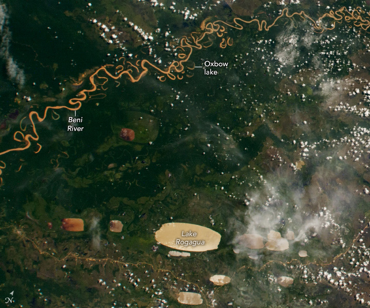
This photograph, taken by a crew member aboard the International Space Station, shows part of the Bolivian Yungas. The heavily forested ecoregion is in the lowlands of the Andes and neighbors the highlands of the Amazon rainforest.
The section of the Beni River pictured here flows northeast as it meanders across the lowlands. The sinuous river channel (brown) is juxtaposed against the vegetated floodplain (green). As it flows through the lush, topographically complex landscape, the water carries a heavy sediment load that accumulates at the river’s curves. The transport and deposition of sediment erodes the riverbank, causing remnants of the main river channel to cut off and form oxbow lakes.
The image also includes several examples of “oriented lakes” that are also known as “lagos cuadrados” (square lakes) because of their rectangular shape. Lake Rogagua is one of the largest of dozens of such lakes in central South America. The lakes, only a few meters deep, are notably oriented in the same direction with their long axes positioned northeast to southwest.
Some scientists think that the pattern relates to the dominant wind direction in South America’s recent geological past. At the time, the landscape was drier and vegetation cover was thinner or absent, which allowed winds to excavate shallow depressions in the landscape. The depressions later filled with water when the climate became wetter.
https://earthobservatory.nasa.gov/images/151450/the-bolivian-lowlands
1 replies
 = new reply since forum marked as read
Highlight:
NoneDon't highlight anything
5 newestHighlight 5 most recent replies
The Bolivian Lowlands (Original Post)
Judi Lynn
Jun 2023
OP
Judi Lynn
(164,039 posts)1. Lakes Pueyrredn and Posadas

September 15, 2020JPEG
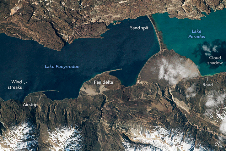
An astronaut onboard the International Space Station shot this photograph of Lake Pueyrredón and Lake Posadas in the Patagonia region of southern Argentina. Snow-covered foothills of the Andes Mountains appear along the lower margin. Streaks on the lake surface are produced by the strong winds that are very common in the region. The dark shadow of a cloud falls on the surface of Lake Posadas. Though the permanent population is small, tourism brings many people to Patagonia’s lake region; the small airstrip and lakeside road aid with arrivals.
Rivers from the local hills have dumped sediment on the shores of the lakes to form small deltas. Three are prominent on the shore of Lake Pueyrredón. (To the west in Chile, Lake Pueyrredón is known as Lake Cochrane.) Very strong and persistent winds have generated waves and currents powerful enough to erode sand from the toes of the fan-deltas, creating long, thin sand spits pointing down-current.
The biggest delta is connected to the opposite shore by a sand bar 3.5 kilometers (2.2 miles) long; it actually may be an ancient moraine. This sand bar cut off the eastern end of Lake Pueyrredón to form the smaller Lake Posadas. Posadas is lighter in color because of the light-toned sediment flowing into it from the incoming river.
Land surfaces here have been dynamic in the past one or two million years. Geologists now know that ice sheets that formed along the nearby Andes Mountains have expanded repeatedly, each time covering almost the entire area shown in the photo. Other astronaut photos such as this one show the Northern Patagonian ice sheet that affected Lake Pueyrredón.
https://earthobservatory.nasa.gov/images/148901/lakes-pueyrredon-and-posadas