Odds of a 'super El Nino' increase, adding to fears of extreme weather around the world
Source: NBC News
May 6, 2026, 5:59 PM EDT
One of the most powerful El Niño events ever recorded could form in the coming months, according to new forecasts, raising concerns about global temperatures, hurricanes, drought conditions and other extremes this year. For several months, forecasters have been predicting a possible “super El Niño” that could emerge and persist through the end of 2026. New forecasts this week from the National Oceanic and Atmospheric Administration and the European Center for Medium-Range Weather Forecasts show those odds are increasing.
An El Niño event is characterized by warmer-than-usual sea surface temperatures in parts of the Pacific Ocean. This natural climate pattern tends to boost global temperatures and can influence weather conditions around the world. El Niño events typically exacerbate background warming from human-caused climate change, increasing the likelihood of hotter-than-normal global temperatures.
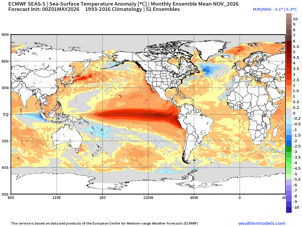
The European center’s latest prediction shows that sea surface temperatures in the central equatorial Pacific Ocean could be as high as 3 degrees Celsius (5.4 degrees Fahrenheit) above average by the fall. If so, that would make this El Niño event one of the most powerful on record and could qualify it as a “super El Niño.”
A super El Niño is an exceptionally strong El Niño, and is defined by water temperatures that are at least 2 degrees Celsius (3.6 degrees F) above average in the Pacific Ocean. NOAA’s outlook, released on Monday, said that “near-to-above average” sea surface temperatures “expanded across most of the equatorial Pacific Ocean” since mid-April.
Read more: https://www.nbcnews.com/science/science-news/super-el-nino-global-weather-heat-rcna343928
Link to NOAA ENSO FORECAST (PDF) - https://www.cpc.ncep.noaa.gov/products/analysis_monitoring/lanina/enso_evolution-status-fcsts-web.pdf
Link to tweet
@RyanWeather
·
Follow
Updated El Niño forecast for this summer/autumn is "off the charts" EXTREME with "boiling red 🔴" map colors along Equatorial central and eastern Pacific Ocean.
This is "Code Red" for the Earth's climate system going into Summer 2026 --> suppressed Atlantic hurricane activity.
Image
9:15 AM · May 5, 2026
El Nino tends to facilitate strong bouts of "westerlies" that clash with the regular easterly trade winds to shear storm systems in or near the Gulf of Mexico, apart (thus suppressing hurricanes in that area).
 = new reply since forum marked as read
Highlight:
NoneDon't highlight anything
5 newestHighlight 5 most recent replies
= new reply since forum marked as read
Highlight:
NoneDon't highlight anything
5 newestHighlight 5 most recent replies

mwmisses4289
(4,961 posts)the Mayon volcano eruption will help keep temperatures down?

AverageOldGuy
(4,289 posts). . . this bumper sticker that I saw yesterday on a jacked-up, shiny, new Ford F-350 pickup?

BigmanPigman
(55,716 posts)CA has experienced the warmest March in a loooooong time.
Meanwhile the GOP is cutting FEMA and govt funding.
dave99
(368 posts)BigmanPigman
(55,716 posts)
FakeNoose
(42,797 posts)It's going to become the NEW NORMAL - the way things are.


Dr. T
(779 posts)because they seem to be happening every ... fucking ... year.

BlueWavePsych
(3,447 posts)


ananda
(35,681 posts)It means fewer and less strong Atlantic hurricanes.
But overall... not good.

BumRushDaShow
(172,979 posts)does forecasts and issues ENSO (EL NIÑO/SOUTHERN OSCILLATION) Advisories. The latest one was last month - https://www.cpc.ncep.noaa.gov/products/analysis_monitoring/enso_advisory/ensodisc.shtml
A new one should be out shortly.
Lots more here - https://www.cpc.ncep.noaa.gov/products/precip/CWlink/MJO/enso.shtml